WELCOME!

The Florida’s Turnpike Enterprise appreciates your interest in this project. Please use the navigation menu to view public hearing videos and display boards. Clicking on the graphic will enlarge the view. The display boards are available for download on the main project website under the Documents section. If you wish to submit comments, please use the comment form below.

The Florida’s Turnpike Enterprise’s welcomes you to the public hearing for the Florida’s Turnpike Widening from Jupiter to Ft. Pierce Project Development and Environment Study. We appreciate your attendance and participation.

Persons wishing to express their concerns about Title VI compliance may do so by contacting either the Florida’s Turnpike Enterprise, or the Tallahassee office of the Florida Department of Transportation.

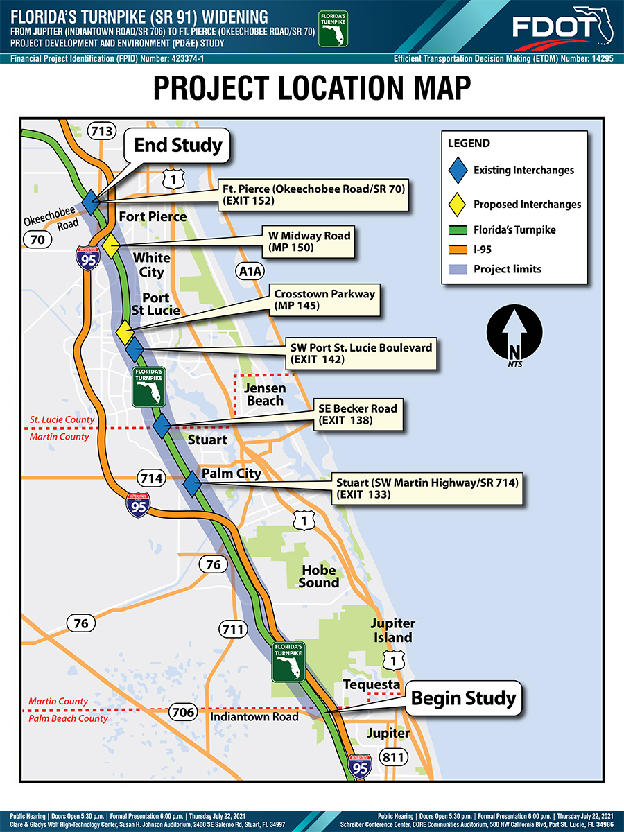
The limits of this project are from north of Indiantown Road (State Road 706) to north of Okeechobee Road (State Road 70). The length of the project is approximately 37 miles.

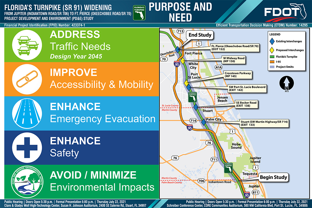
The purpose and need for a project provide the basis for developing, evaluating, and eliminating project alternatives. This project’s purpose and need are to address forecasted Year 2045 traffic needs, improve long term mobility, enhance emergency evacuation, and enhance safety, while avoiding or minimizing environmental impacts.

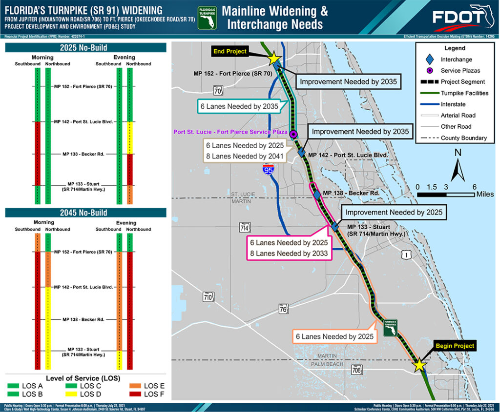
The traffic analysis results identified the year when improvements are needed.  The year of need is provided for the widening of Florida’s Turnpike and improvements to the existing interchanges.


This graphic is available for download on the main project website (www.TreasureCoastTurnpike.com) under the Documents section.

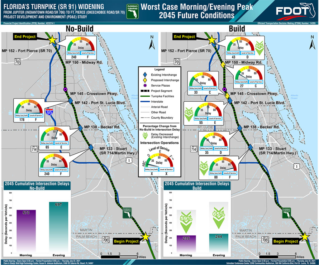
The traffic analysis results identified the Level of Service and Delay for the No Build and Build conditions in the year 2045.  The Level of Service and Delay is for the interchanges along the project corridor.


This graphic is available for download on the main project website (www.TreasureCoastTurnpike.com) under the Documents section.

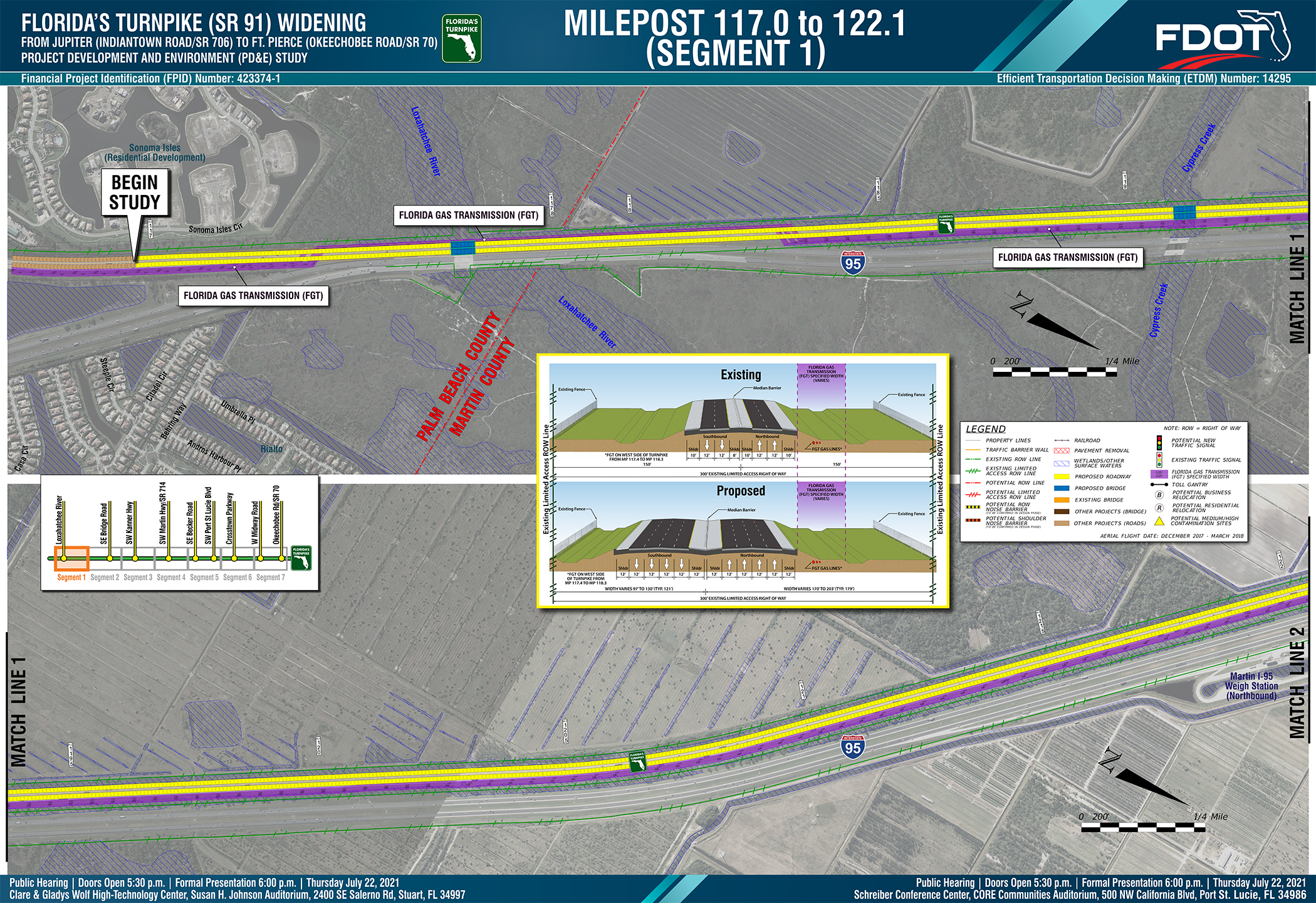
This Concept Plan shows the preferred alignment for the Florida’s Turnpike Widening from the start of the project at milepost 117.0, north of Indiantown Road (State Road 706), to milepost 122.1. The legend on the board provides a visual explanation of the symbols and lines used. Typical sections detailing the existing and proposed roadway cross sections are also provided on the board.  Within this segment of the project, the Turnpike crosses the Loxahatchee River and Cypress Creek.  Bridges at both of these locations will be replaced and widened as part of this project.


The mainline Concept Plan graphics are available for download on the main project website (www.TreasureCoastTurnpike.com) under the Documents section.
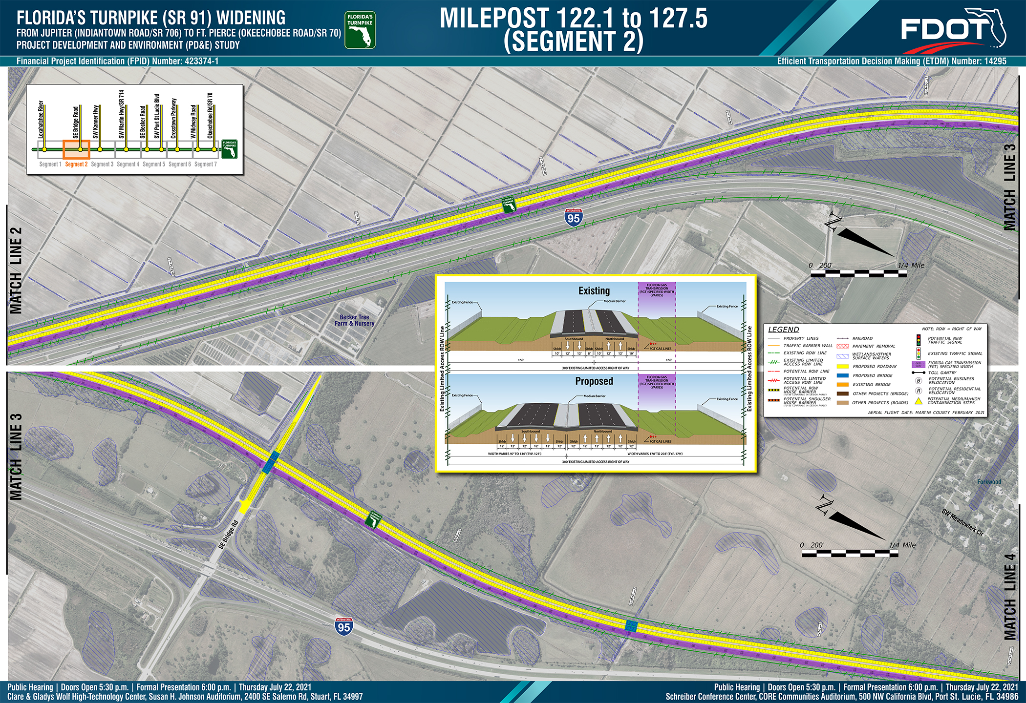
This Concept Plan shows the preferred alignment for the Florida’s Turnpike Widening from milepost 122.1 to milepost 127.5. The legend on the board provides a visual explanation of the symbols and lines used. Typical sections detailing the existing and proposed roadway cross sections are also provided on the board. Within this segment of the project, the Turnpike crosses under SE Bridge Road (County Road 708), and over an un-named tributary to the South Fork of the St. Lucie River. The existing bridges at these locations will be replaced and the bridge over SE Bridge Road will be lengthened as part of this project.


The mainline Concept Plan graphics are available for download on the main project website (www.TreasureCoastTurnpike.com) under the Documents section.
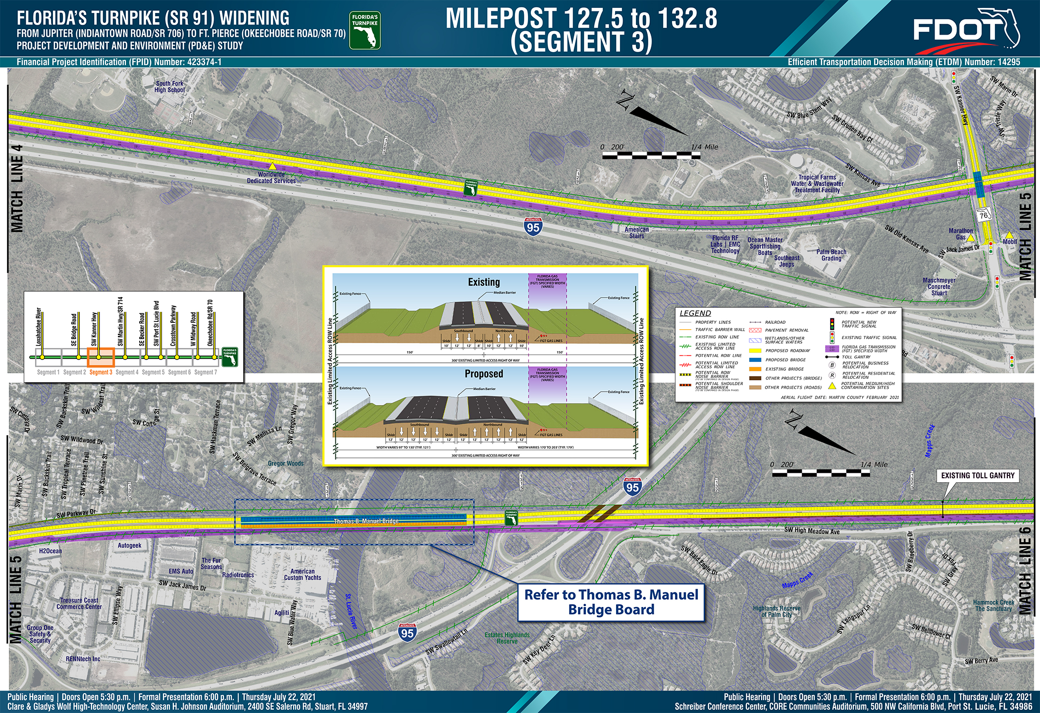
This Concept Plan shows the preferred alignment for the Florida’s Turnpike Widening from milepost 127.5 to milepost 132.8. The legend on the board provides a visual explanation of the symbols and lines used. Typical sections detailing the existing and proposed roadway cross sections are also provided on the board.  Within this segment of the project, the Turnpike crosses under SW Kanner Highway, over Roebuck Creek and the St. Lucie River and under Interstate 95. As part of this project, the SW Kanner Highway Bridge will be replaced and lengthened. The Thomas B. Manuel southbound bridge over Roebuck Creek and the St. Lucie River will be replaced and widened and the Thomas B. Manuel northbound bridge over Roebuck Creek and the St. Lucie River will be widened. The Interstate 95 bridges over the Turnpike will be replaced as part of a separate project.


The mainline Concept Plan graphics are available for download on the main project website (www.TreasureCoastTurnpike.com) under the Documents section.
This Concept Plan shows the preferred alignment for the Florida’s Turnpike Widening from milepost 132.8 to milepost 138.1. The legend on the board provides a visual explanation of the symbols and lines used. Typical sections detailing the existing and proposed roadway cross sections are also provided on the board. Within this segment of the project, improvements are proposed to the Turnpike’s interchange at SW Martin Highway (State Road 714). In addition, the Turnpike crosses an unnamed tributary to Bessy Creek and the County Line Canal. The bridges at both these locations will be replaced and widened as part of this project.


The mainline Concept Plan graphics are available for download on the main project website (www.TreasureCoastTurnpike.com) under the Documents section.
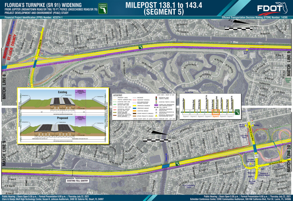
This Concept Plan shows the preferred alignment for the Florida’s Turnpike Widening from milepost 138.1 to milepost 143.4. The legend on the board provides a visual explanation of the symbols and lines used. Typical sections detailing the existing and proposed roadway cross sections are also provided on the board. Within this segment of the project, improvements are proposed to the Turnpike’s interchanges at SE Becker Road and SW Port St. Lucie Boulevard. In addition, the Turnpike crosses the C-23 (County Line) Canal. The bridges at SE Becker Road and Port St. Lucie Boulevard will be replaced and lengthened, while the bridge over the C23 Canal will be replaced and widened as part of this project.


The mainline Concept Plan graphics are available for download on the main project website (www.TreasureCoastTurnpike.com) under the Documents section

This Concept Plan shows the preferred alignment for the Florida’s Turnpike Widening from milepost 143.4 to milepost 148.7. The legend on the board provides a visual explanation of the symbols and lines used. Typical sections detailing the existing and proposed roadway cross sections are also provided on the board. Within this segment of the project, a new partial interchange is proposed at Crosstown Parkway. In addition, the Turnpike crosses under SW St. Lucie West Boulevard. The bridge at SW St. Lucie West Boulevard will be replaced and lengthened as part of this project.


The mainline Concept Plan graphics are available for download on the main project website (www.TreasureCoastTurnpike.com) under the Documents section.
This Concept Plan shows the preferred alignment for the Florida’s Turnpike Widening from milepost 148.7 to the end of the project at milepost 153.7. The legend on the board provides a visual explanation of the symbols and lines used. Typical sections detailing the existing and proposed roadway cross sections are also provided on the board. Within this segment of the project, a new interchange is proposed at W Midway Road and improvements are proposed to the Turnpike’s interchange at Okeechobee Road (State Road 70). In addition, the Turnpike crosses over Tenmile Creek. The bridge at Glades Cut Off Road will be replaced and lengthened, and bridge at Tenmile Creek will be replaced and widened as part of this project.


The mainline Concept Plan graphics are available for download on the main project website (www.TreasureCoastTurnpike.com) under the Documents section.
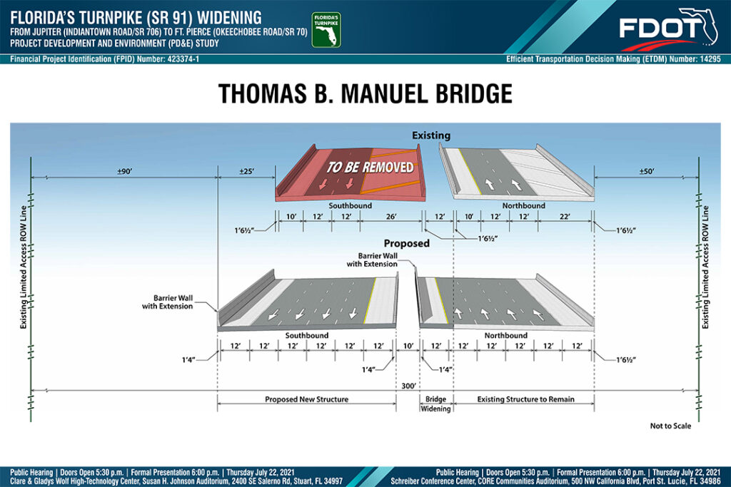
The Thomas B. Manuel Bridge structures cross the St. Lucie River and Roebuck Creek north of SW Kanner Highway in Martin County.  There are two structures associated with this bridge, a southbound and northbound structure, each of which are approximately 56 feet wide. As part of this project, the southbound structure will be replaced and widened, and the northbound structure will be widened, resulting in new structures each approximately 72 feet wide.  All widening of these structures will be done to the west of the existing structures. In addition, a 2.25-foot visual barrier will be constructed along the top of the west barrier wall of both the northbound and southbound bridges.  The existing and proposed structures are shown in cross section on this graphic.


This graphic is available for download on the main project website (www.TreasureCoastTurnpike.com) under the Documents section.
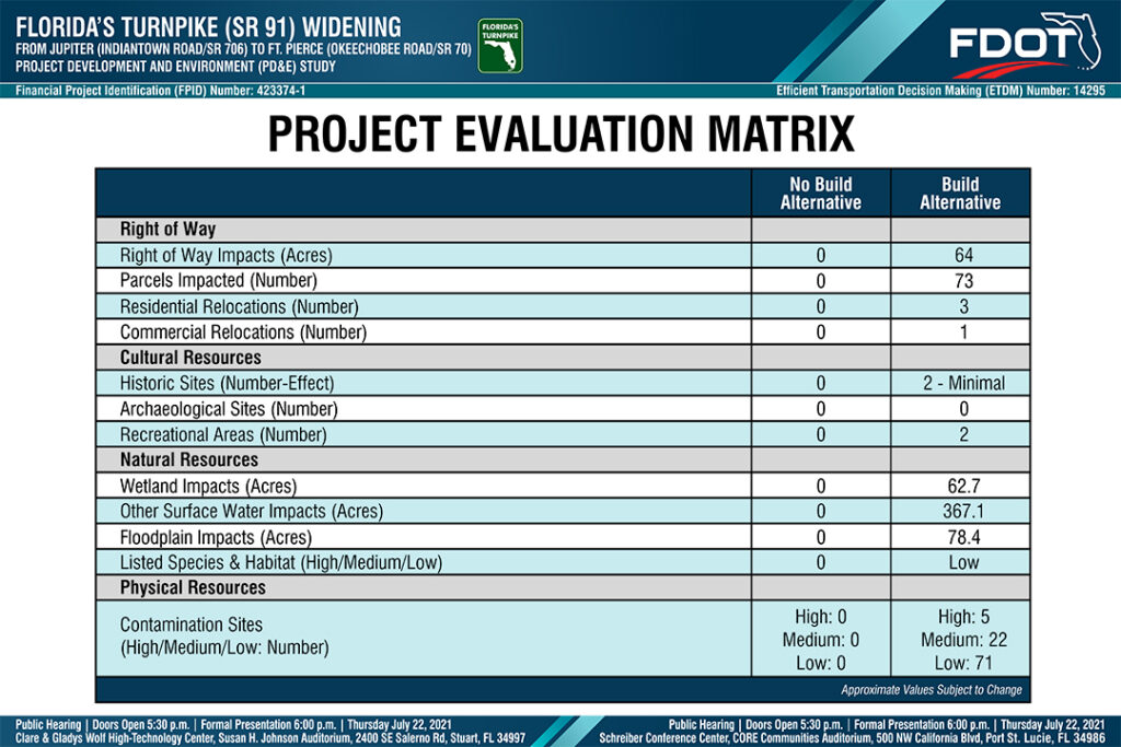
The preferred alternative was evaluated to analyze potential effects to the social, cultural, natural, and physical environment in accordance with state and federal regulations. The evaluation matrix shown here summarizes the evaluation results.

This graphic is available for download on the main project website (www.TreasureCoastTurnpike.com) under the Documents section.
Preliminary cost estimates for the completion of the preferred mainline and interchange alternatives were developed. The table shown here summarizes the preliminary cost estimates for each of these project components and provides the preliminary cost of the overall project.


This graphic is available for download on the main project website (www.TreasureCoastTurnpike.com) under the Documents section.

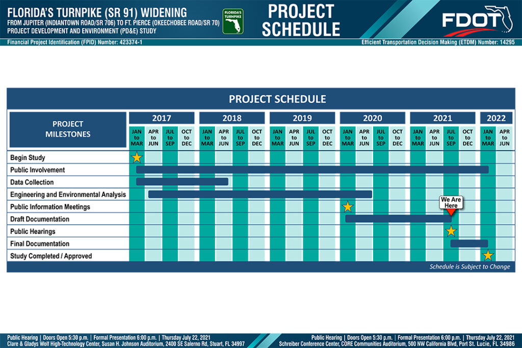
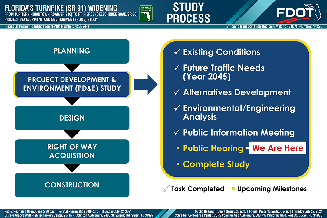
The PD&E Study of the Florida’s Turnpike Widening from north of Indiantown Road (State Road 706) to north of Okeechobee Road (State Road 70) was started by Florida’s Turnpike Enterprise in Winter 2016/2017 and is scheduled for completion in Winter 2021/2022.


This graphic is available for download on the main project website (www.TreasureCoastTurnpike.com) under the Documents section.
COMMENT FORM